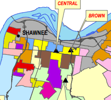
JCPS High School Boundary Map

 When the Supreme Court ruled in 2007 that JCPS could no longer use race as the only factor for determining student assignment, a new boundary map that also took into account household income and education levels was developed and implemented in 2008. In order to achieve equitable distribution of the population by these new factors, the West End/Shawnee community was carved up into more than a dozen pieces and assigned to resides schools that were further from home than their nearest high school. Furthermore, in order offset the population that is bused away from home, students from Portland and Highland areas are bused in (the grey area).
If the goal of this new student assignment map was diversity and equitable access to quality education, why doesn’t busing go both directions instead of just West to East? Consider what impact this burden has had over the last 8 years on:
- Parental involvement in student’s education
- Parental involvement in school programs
- Parent/teacher communication regarding student achievement and/or discipline, P/T conferences
- Student involvement in after-school activities
- Educational outcomes, closing of “gap” in test scores
- Sense of community/neighborhood
- Ability to advocate around common interests
- Community involvement/pride in local school
- Quality schools in every neighborhood
- Travel time for students and parents
- Ability to identify and direct in-school supports where needed most
- Student safety (students often walk home)
With increasing challenges in JCPS, Louisville, and education in general, isn’t it time we revisit this map? Shouldn’t ALL students have the same opportunities: a choice between a quality public school in their neighborhood, as well as equitable access to schools of choice across the district, regardless of where they live?

